Reaction to Jensen Huangs Keynote speech at GTC 2026
Published on: 18 March 2026
Written by Michael Jendryke
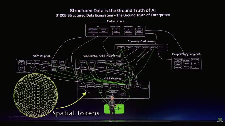
Jensen Huang at NVIDIA GTC: “Structured data is the ground truth of AI.”
Finally. Thank you!
This is the same insight Kyoung-Sook Kim articulated about the need for some tokenization. The same principle behind why we built spatial tokenization and Discrete Global Grid Systems hashtag#DGGS. The same reason GeoInsight is part of the NVIDIA Inception program.
It’s all connected.
AI doesn’t work on chaos. It works on structure. Give it raw, unorganized inputs and you get unreliable outputs. Give it structured representations where relationships are encoded, and suddenly patterns emerge. This applies everywhere - language, vision, time series. And absolutely to spatial data.
Here’s what makes Jensen’s statement particularly interesting for the geospatial world: he used the term “ground truth.”
In Earth observation, ground truth means validated field measurements - the actual reality we verify our satellite observations against. What’s on the ground, literally.
In AI, ground truth means the foundational structured data that models learn from. The reliable reference that everything else builds upon.
Two different meanings. Same fundamental concept: you need a solid, structured foundation.
But here’s the problem: most geospatial data today isn’t structured in the way Jensen means.
We have layers. We have files. We have databases. But we don’t have inherent spatial structure that encodes relationships, hierarchy, and proximity in a form AI can learn from natively.
Lat/long pairs? Just floating point numbers. Raster tiles? Arbitrary pixel grids. Vector geometries? Complex polygons with no inherent spatial grammar. None of these are “structured” for AI. They’re structured for human interpretation via maps and GIS software.
This is why spatial tokenization matters. It transforms geographic data into structured representations where:
The data becomes its own grammar.
When Jensen says structured data is the ground truth of AI, he’s describing what we’ve been building for geographical context. A way to make location data legible to machines, not just humans.
Whether you’re working with language, images, sensor data, or geography - the pattern is the same: structure first, machine learning follows.
This isn’t about any single technology. It’s about recognizing that if you want AI to reason about something, you need to give it structured representations of that domain.
For language: tokens. For images: embeddings. For location: spatial tokens. The ground truth of spatial AI isn’t the satellite imagery or the coordinates. It’s the structured representation that makes geographic relationships learnable.
Jensen nailed it. Structured data is the ground truth.
Now let’s make sure spatial data gets there too.
Here is the Keynote speech recording